Hello everybody.
Many of you are pleased to collect, trade and identify coins and gather the stories behind them - and rightfully so. Coins are indeed fascinating in their own right. I was wondering who uses numismatics to answer academic questions, perhaps not necessarily related to the coins themselves. I'd like to start off by giving a small example of my MA thesis
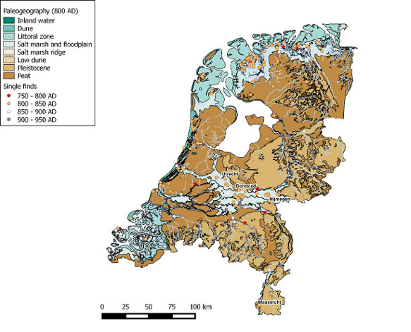
During my MA programme in archaeology however, I became interested in coinage and their distribution patterns as a potential proxy for activity (habitation of areas, exchange, et cetera) and site formation processes that make coins come to light (or obscure them). This I will do by using Geographical Information Systems to analyse the coins in relation to certain landscape layers (geological, topographical, hydrological, etc.), such as the paleogeographic map of the Netherlands of +- 800 AD. I am particularly interested in Carolingian coinage (roughly 750 to 950 AD) in the Netherlands. My thesis is nearly finished and I'd be glad give a superficial sneak peak at a type of analysis.
I give the example of the paleogeographic map of the Netherlands. When I started off, I had some basic hypotheses about where distribution was likely to take place.
* I expected very few coins around areas rich in peat and sand. Peat (large areas of the west and north of the Netherlands) was detrimental to farming and habitation, and those areas are assumed to have been sparsely inhabited. Sandy pleistocene cover sand regions were supposedly at least somewhat inhabited during the early Middle Ages, but sandy soil mineralised soil appears to heavily corrode coins in combination with water. Though the areas were inhabited, fewer coins are expected.
* I hypothesised a strong correlation with floodplains in riverine areas and near the coast. Both the sea and the Rhine and Meuse rivers were arteries of trade during the Carolingian era (as they were before and after). River banks were popular places for habitation. Especially Dorestad - the premier trade emporium of the Carolingian era - is expected to be rich in coins, as are areas near the sea as Frisians (very active traders) lived on artificial mounds within the bountiful salt marshes near the sea.
* Obviously, a correlation with current urban areas can be expected, as many urban areas were also populated during the middle ages. Perhaps even more importantly, this is where detectorists will readily search.
All these basic hypotheses proved to be correct, as the following picture will show.
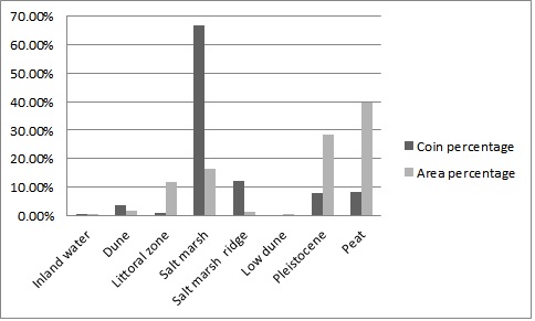
And the corresponding statistics. This shows the size of the paleogeographic areas in relation to the entire Netherlands (which should be equal to the amount of coins found in those landscapes if distribution was equal or random). It also shows the 'real' percentage of coins found in each geographical feature. You can easily sea that the riverine/sea areas have an abundant amount of coins, whereas areas rich in peat and sand do not.
Last example is a game of 'spot the differences' with time slices of 50 years.
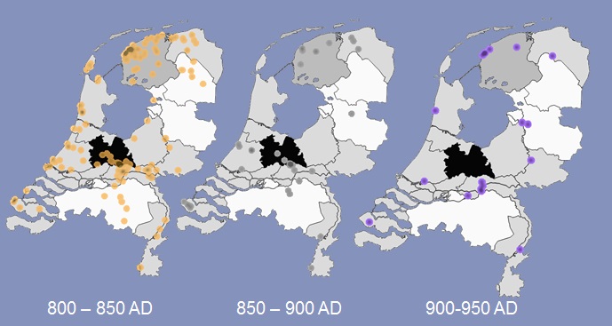
Easily seen in the latter two time slices is that distribution near the coastal areas almost completely ceased except for some remnants in the province of Friesland (top left province). The possible âtrade route' or line of coins visited in Noord-Brabant (the southern middle province), or indeed any activity in Noord-Brabant ceased as well.
Especially striking is the last image complete absence of coins in Utrecht, including Dorestad - - " consequently, Tiel (slightly south of Dorestad) remained active. The last remaining vestiges of coins are mostly inland, and some interesting appearances can be seen in both Zwolle and Zutphen along the IJssel river. There are of course many reasons for these changes in distribution during these 150 years.
Hopefully this was not too boring. This is of course extremely superficial as I will not bore you with my entire thesis, but coin distribution in combination with statistical packages can be incredibly interesting for both practical reasons (where can I expect certain coins?) and theoretical (why did distribution exist and change the way it did?).
Thank you for your attention. I'd really love to hear if anybody else uses coins as a tool to ask questions in relation to societies too. This need not be distribution analysis, obviously - it's just that GIS and statistics is something I greatly enjoy in combination with archaeology. In the future I hope to apply similar methods to Anglo-Saxon, Frisian and Roman coinage. I'm a bit of a GIS geek, so if anybody needs help with making presentable maps or analyses please do not hesitate to ask.